
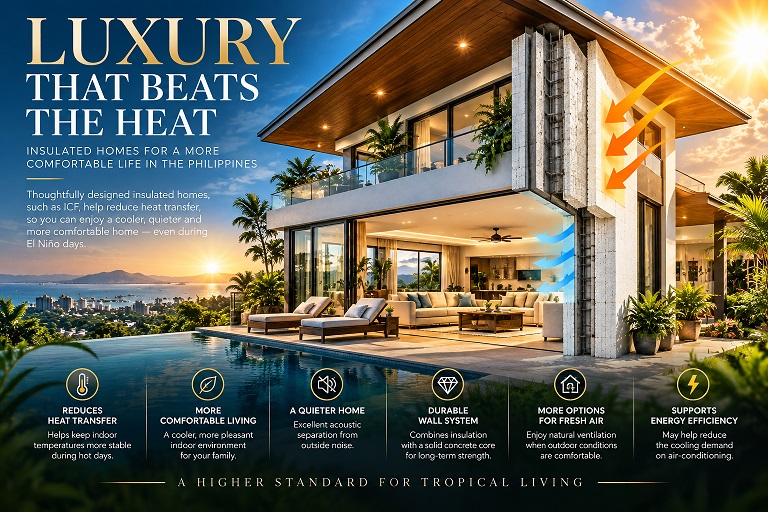
For many homeowners, a luxury home means beautiful finishes, expansive rooms, elegant kitchens, imported fixtures, and impressive views. But there is another form of luxury that is often overlooked: being comfortable inside your home without having to rely on air-conditioning every hour of the day. This becomes particularly relevant during periods of intense heat associated with El Niño.
In the Philippines, air-conditioning has become almost synonymous with comfort. When the afternoon becomes hot and humid, windows are closed, curtains are drawn, and the air conditioner is switched on. Hours later, the house may be comfortable, but the occupants have spent much of the day inside mechanically conditioned spaces. For homeowners with a higher budget, there is another approach worth considering: design the house itself to manage heat. The objective is not to eliminate air-conditioning, but to create a home where air-conditioning is used intelligently while the building envelope, shading, insulation, windows, and natural ventilation do more of the work.
Imagine Opening the Windows Again
One of the pleasures of living in a tropical country is being able to experience the outdoors. A gentle breeze through an open window, morning sunlight entering the bedroom, the sound of rain, the smell of vegetation after a shower, and fresh outdoor air moving through the living room can all contribute to the experience of living in the Philippines. Yet many modern homes make opening the windows uncomfortable during the hottest parts of the day. Without adequate insulation and solar protection, outdoor heat can quickly enter the house. Large unshaded windows can introduce substantial solar heat, while hot exterior walls and roofs can transfer heat inward. The result is predictable: windows are closed, the air conditioner is turned on, and the house becomes dependent on mechanical cooling.
A high-performance tropical home approaches the problem differently. It begins by reducing the amount of heat entering the house in the first place, allowing the occupants greater flexibility in deciding when natural ventilation is appropriate and when mechanical cooling is necessary.
ICF and the High-Performance Building Envelope
Insulated Concrete Forms, or ICF, are one construction approach that can help achieve this objective. ICF walls combine insulating forms with a reinforced concrete core. The insulation provides resistance to heat transfer while the concrete provides substantial thermal mass and structural capacity when properly engineered. The result is a wall system designed not simply to separate one room from another, but to form part of the home’s thermal envelope.
For a premium residence, this can be combined with other strategies to create a more comprehensive approach to tropical comfort. The wall is only one part of the equation. The roof, windows, doors, shading, orientation, ventilation, and mechanical systems must all work together if the goal is to create a genuinely comfortable and efficient home.
The Goal Is Not to Fight the Climate With Air-Conditioning
A conventional approach to a hot house is relatively simple: when it gets hot, the windows are closed and the air conditioner is turned on. A high-performance approach asks a different question: why is the house getting hot so quickly in the first place? The answer may include direct solar radiation through windows, heat entering through the roof, heat transfer through exterior walls, air leakage, poor orientation, insufficient shading, or inadequate insulation. Addressing these factors can reduce the building’s heat gain and allow the air-conditioning system to operate under less demanding conditions when it is needed.
More importantly, during periods when outdoor conditions are actually comfortable enough for natural ventilation, the occupants may have greater flexibility to open windows and enjoy the outdoor air. This is not always possible in the middle of a hot and humid afternoon, but a properly designed building can provide more opportunities for natural ventilation during cooler mornings, evenings, or periods when outdoor conditions are favorable.
El Niño Makes This Conversation More Relevant
El Niño does not mean that every day will be unbearably hot, nor does it mean that rain will disappear completely. Weather changes from day to day, and there may still be cloudy mornings, thunderstorms, breezy afternoons, and periods of pleasant weather. The challenge is that prolonged hot and sunny periods can increase the amount of heat absorbed by buildings.
For a conventional poorly insulated home, that heat can accumulate rapidly. For a carefully designed insulated home, heat transfer can be slowed. This does not make the house immune to outdoor conditions, but it can give the building greater thermal resistance and help maintain more stable interior conditions.
The Luxury of Using Air-Conditioning by Choice
There is a difference between needing air-conditioning constantly and having air-conditioning available whenever you want it. That distinction can be particularly attractive to homeowners who are building high-end residences.
Imagine a home where the morning begins with open windows and natural airflow. As the day warms, the windows can gradually be closed and shaded areas maintained. If temperatures become uncomfortable, efficient inverter air-conditioning can be used. Later in the evening, when outdoor conditions become favorable again, the house can return to natural ventilation.
This is not necessarily possible every day. Cebu can be hot and humid, and outdoor air quality, insects, noise, security, and weather conditions must also be considered. But a house designed for thermal performance can provide more options. For a luxury home, that flexibility is itself a form of comfort.
Fresh Air Requires More Than Opening a Window
There is an important distinction between natural ventilation and simply opening windows. A successful tropical ventilation strategy considers the direction of prevailing winds, window placement, room arrangement, building orientation, shading, cross-ventilation paths, and the relationship between indoor and outdoor spaces.
Large openings positioned correctly can allow air to move through living areas, while opposing windows can create cross-ventilation. High-level openings can also assist with the removal of accumulated warm air. Covered terraces and shaded outdoor spaces can provide transitional areas between the fully conditioned interior and the outdoors. This is where architectural design becomes more important than any individual construction material.
Windows Should Be Designed for the Sun
Large glass windows are beautiful. They can bring daylight into a room and connect the interior with gardens, pools, mountains, or the sea. But glass can also be one of the largest sources of solar heat gain, particularly when large windows face strong afternoon sunlight without adequate shading.
A premium tropical home therefore needs to treat windows as a carefully engineered part of the building envelope. Window orientation, glazing performance, external overhangs, vertical shading elements, balconies, canopies, curtains, and landscaping can all help control solar exposure. The objective is not necessarily to have fewer windows, but to have better-performing windows in better locations.
The Roof Deserves Equal Attention
A beautiful roof can still turn a house into an oven if its thermal performance is ignored. The roof is exposed to intense tropical sunlight for hours at a time, and heat can accumulate in the roof assembly and eventually reach the occupied spaces below.
For this reason, a premium insulated home should consider the roof and ceiling assembly just as carefully as the walls. Appropriate insulation, reflective roofing materials, roof ventilation where suitable, and careful detailing can help reduce heat entering the living spaces. The result is a building envelope designed as a whole rather than a collection of individual components.
A Quieter Home as an Added Benefit
There is another reason some high-end homeowners choose substantial insulated wall systems: acoustic comfort. The combination of concrete mass and insulation can help reduce the transmission of outside noise compared with some lightweight wall systems.
For a residence located near a busy road, commercial district, construction activity, or densely populated neighborhood, a quieter interior can become almost as important as thermal comfort. A peaceful bedroom, a quiet home office, and a living room protected from traffic noise are valuable features that may not appear on a standard list of luxury finishes.
More Than an ICF House
A genuinely high-performance tropical residence should not be defined simply by the words “ICF house.” ICF can be one component of the overall strategy. A premium home might combine ICF or another high-performance insulated wall system with high-performance roof and ceiling insulation, solar-control glazing, deep roof overhangs, exterior shading, carefully positioned windows, cross-ventilation, efficient inverter air-conditioning, appropriate building airtightness, thoughtful orientation, landscaping for shade, and covered outdoor living spaces.
Together, these features can create a home that responds intelligently to the Philippine climate. ICF may be an appropriate structural and thermal solution for some projects, while other insulated wall systems may make more sense for different budgets, architectural requirements, or construction conditions.
The Real Luxury Is Choice
Perhaps the greatest advantage of a high-performance insulated home is not simply a lower electricity bill. It is choice: the choice to open the windows when the weather is pleasant, enjoy a morning breeze, spend time on a shaded terrace, close the house and use efficient air-conditioning when the afternoon becomes uncomfortable, or create a quiet and stable interior when outside conditions are unpleasant.
Instead of forcing the occupants to live in one mode all year, the house can adapt to changing conditions. That ability to adapt can be particularly valuable in a tropical country where weather conditions can change considerably throughout the day.
Building for the Next Several Decades
El Niño will eventually pass, but the Philippine climate will remain tropical. A house built today may be occupied for several decades, so it makes sense to consider not only today’s construction cost but also the comfort and performance of the building throughout its lifetime.
For homeowners investing in a premium residence, thermal performance should be considered alongside architecture, structural engineering, interior design, landscaping, security, technology, and finishes. The most expensive home is not necessarily the most comfortable. A truly sophisticated home is one in which the architecture itself contributes to comfort.
The High-End Tropical Home
For those willing to invest more in construction, insulation and passive design can move beyond the idea of simply keeping the house cool. The objective becomes something broader: a home that understands the tropical climate, limits unwanted heat, uses shade intelligently, takes advantage of natural airflow when conditions permit, and provides cool, quiet, controlled interiors when the weather becomes extreme.
During the hot days of an El Niño period, that difference can become especially noticeable. Luxury is not simply having a powerful air conditioner. Luxury is having a home designed so that you do not always need it.








Feedback